Regional Watersheds
We protect and sustain the resources entrusted to our care. Learn more about our watersheds, reservoirs, policies, and programs, as well as recreation opportunities.
-
Peninsula

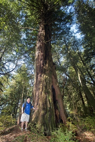
The SFPUC Peninsula Watershed - 23,000 acres of diverse and unique habitats ranging from oak woodlands and coniferous forests to serpentine grasslands is carefully managed to protect the quality of the water in the reservoirs and an abundance of native plant and animal life, including many rare, threatened or endangered species. The Peninsula Watershed is also a State-designated Fish and Game Refuge and a protected area within the UNESCO Golden Gate Biosphere Reserve.
Because of its 150-year history as a protected source of safe, high-quality municipal drinking water, much of the watershed is not open for recreational activity. However, members of the public can still experience for themselves the watershed’s pristine old-growth forests, intimate meadows , and ridgetop vistas by visiting our 10-mile Fifield-Cahill Ridge Trail, or the 17.5-mile Crystal Springs Regional Trail managed by the San Mateo County Parks Department.
Ridge Trail Extension Coming
We are also developing a new and enhanced Ridge Trail extension that will link the existing trail with the Golden Gate Recreation Area (GGNRA) Phleger Estate to the south. It will create a single 16.5-mile trail across the 23,000-acre watershed and provide more educational opportunities within the watershed that are compatible with the need to protect drinking water quality and the watershed’s fragile ecosystems.
Watershed Management Plan
The purpose of the Peninsula Watershed Management Plan is to provide a policy framework for the SFPUC to make consistent decisions about the activities, practices, and procedures that are appropriate on SFPUC watershed lands. To aid the SFPUC in their decision-making, the plan provides a comprehensive set of goals, policies, and management actions which integrate all watershed resources and reflect the unique qualities of the watersheds.
Access Other Nearby Public Lands
-
Alameda

The Alameda Watershed lands include 30,000 acres of primary watershed, lands which are tributary to San Antonio and Calaveras Reservoirs, as well as lands which drain into Alameda Creek above the Fish Release and Recapture Facility. The primary watershed lands are the most sensitive lands in terms of water quality protection. Alameda Watershed Lands also include 6,000 acres of secondary watershed.
Land Use
A portion of the Alameda Watershed lands are leased by and produce revenue for us from a variety of uses including grazing, plant nurseries and quarry operations. Several utility companies have easements for routing of public utilities such as gas pipelines, electrical transmission lines and water aqueducts. A portion of our lands are also leased by the East Bay Regional Park District as part of the Sunol-Ohlone Regional Wilderness. The portion operated by the District includes many pedestrian, equestrian, and bicycle trails.
Open public access to interior parts of our watershed lands is prohibited because of the risk of fire and potential degradation of water quality and natural resources. We do however, allow access to some internal fire roads by permit for research or educational purposes to groups accompanied by volunteer leaders.
Geology
The southern portion of the Alameda Creek Watershed drains a 175-square mile area that includes Mount Hamilton. This dry and rugged Watershed has a varied topography that ranges from flatlands to areas of over sixty percent slope.
The Calaveras fault runs through the central portion of this Watershed, and elevations rise to over 3,000 feet in some areas. Soils in the San Antonio Reservoir area are subject to high erosion because of the steep slopes and the proximity to faults.
An intricate system of streams and tributaries winds through the Alameda Watershed; the main streams on our land include San Antonio, Indian and Alameda Creeks in the north and Calaveras, Arroyo Hondo and Alameda Creeks in the south.
Natural Environment
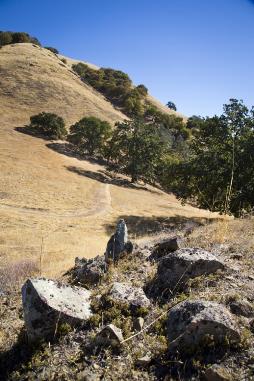
The Alameda Watershed provides habitat for a variety of wildlife. Grassland communities cover more than 50 percent of the watershed and woodlands cover about 22 percent. Other habitats include freshwater marshes, where streams discharge into reservoirs, and brush, scrub, and chaparral communities in the flatter, drier, or steeper lands.
Ridgelands and open water make the area an attractive winter foraging and resting habitat for migrating and resident bird species, drawing birds of prey, waterfowl, and perching birds. In total, the watershed contains more than 17 types of wildlife habitat that support a range of animals, including tule elk, black-tailed deer, coyote, mountain lions, and bald eagles.
Cattle have grazed on the Alameda Creek Watershed for more than a century. Strict grazing management practices -- from fencing creeks to keep out livestock to limiting the number of animals allowed in the watershed -- have helped maintain high water quality and reduce the threat of wildfire. Grazing is considered an important tool in managing fire, because it reduces the amount of grass and other vegetation that might quickly ignite if left unmanaged during the area's hot, dry summers.
Management Plan
The purpose of the Alameda Watershed Plan is to provide a policy framework for the SFPUC to make consistent decisions about the activities, practices, and procedures that are appropriate on SFPUC watershed lands. To aid the SFPUC in their decision-making, the plan provides a comprehensive set of goals, policies, and management actions which integrate all watershed resources and reflect the unique qualities of the watersheds.
Location
The Alameda Watershed lands are split between Alameda (23,000 acres) and Santa Clara (13,000 acres) Counties and contain two reservoirs -- the San Antonio Reservoir to the north and the Calaveras Reservoir to the south. Highway I-680 and Route 84 meet in the northern portion of the Watershed, and Calaveras Road extends north-south down the center. Milpitas and Fremont lie to the west and Pleasanton and Livermore are located to the northeast
-
Upper Tuolumne

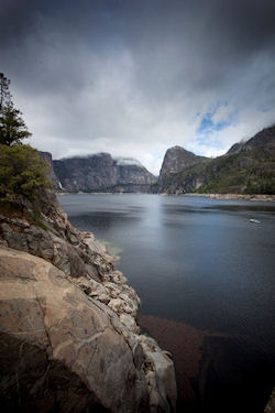
The Tuolumne River, which drains a 1,960 square-mile watershed on the western slope of the Sierra Nevada range, is the largest of three major tributaries to the San Joaquin River. The Tuolumne originates in Yosemite National Park and flows southwest through Yosemite, Stanislaus National Forest, and private lands to its confluence with the San Joaquin River, approximately 10 miles west of Modesto.
At higher elevations, the watershed is composed primarily of granitic bedrock that was scoured by glaciers during glacial periods down to the O’Shaughnessy Dam location, resulting in mountainous terrain, patchy forests, and a variety of steep canyons and mountain meadows. The middle portion of the watershed from New Don Pedro Reservoir to above Hetch Hetchy Reservoir is characterized by deep canyons and forested terrain. Near the town of La Grange, the river exits the Sierra Nevada foothills and flows through a gently sloping alluvial valley that is incised into Pleistocene alluvial fans.
We operate the Hetch Hetchy Project, located within Yosemite National Park and the Stanislaus National Forest in the Upper Tuolumne River watershed. The Hetch Hetchy Project supplies water and power to the City of San Francisco and surrounding Bay Area communities, and regulates stream flow in the Upper Tuolumne River, Cherry Creek, and Eleanor Creek.
We are responsible for environmental stewardship issues related to the operation of Hetch Hetchy Project facilities in the Upper Tuolumne River watershed. Through implementation of our Environmental Stewardship Policy and collaborative efforts, including the Upper Tuolumne River Ecosystem Project, we and project partners are building a scientific understanding of the river with the goal of improving management of the overall river ecosystem.
-
Watershed and Environmental Improvement Program
The Watershed and Environmental Improvement Program is a 10-year, $50 million, program to proactively manage, protect and restore environmental resources affected by our system operations. Funded in part by Water System Improvement Program Measure A bond funds and in part by operating funds, the Program spans the Peninsula, Alameda, and Tuolumne Watersheds, as well areas in San Francisco.

The Program’s objectives are:
- Manage watershed activities and resources to protect source water quality and protect/restore terrestrial and aquatic species and their habitats
- Protect/restore watershed lands
- Enhance public awareness of watershed resources, their protection, and restoration efforts
- Include key stakeholders in the Program
- Maintain up-to-date watershed assessments and management plans
- Develop monitoring and feedback mechanisms to measure progress
We design and implement projects as part of the Program that:
- Are above and beyond normal watershed maintenance activities (e.g. roads, fences, and trails)
- Meet the goals of the Water Enterprise Environmental Stewardship Policy
- Are not already included in any other SFPUC projects, or as mitigation for either the Water System Improvement Program (WSIP), or the Bioregional Habitat Restoration Program for the Alameda Watershed.
Would you like to know more?
Watershed and Environmental Improvement Program Annual Report FY 2015 - 2016
Watershed and Environmental Improvement Program 10 Year Report FY 2006 – 2015

